Jacks River Watershed
Beech Bottom Trail
9.3 mi
Distance
+990 ft
Elevation Gain
out and back
Trail Type
1
Crossings
Overview
The easiest and shortest route to Jacks River Falls — a gentle 4-mile approach through ridgeline forest and river floodplain.
Trail Description
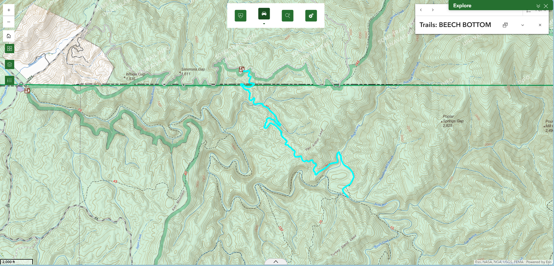
Beech Bottom Trail is the gentlest invitation into the heart of the Cohutta Wilderness. While many trails here demand steep climbs or repeated river crossings, Beech Bottom offers a forgiving grade, modest elevation change, and a clear destination: Jacks River Falls — the most beloved cascade in the wilderness. Beginning in the Cherokee National Forest of Tennessee, the trail follows an old forest roadbed southeast. Within the first quarter mile, you quietly cross into Georgia and the Chattahoochee National Forest — a subtle shifting of jurisdiction but not of landscape. The forest remains deeply Appalachian: mixed oak and hickory (Quercus alba, Carya tomentosa), scattered white pine (Pinus strobus), and, true to the trail’s name, American beech (Fagus grandifolia) whose smooth gray bark catches winter light.
At roughly mile 1, the trail crosses a small creek before beginning a gradual climb of just over 300 feet by mile 2.5. The ascent is steady but never demanding. In winter, when leaf-off opens the canopy, views emerge toward Hemp Top Ridge and Rough Ridge. On clear days, the pyramidal summit of Big Frog Mountain rises distinctly in the distance. After sustained rainfall, you may even hear the distant rumble of Jacks River Falls long before you see it — a low whitewater percussion beneath the wind. Around mile 2.9, a winter vista opens briefly before the trail bends northward along a ridge spine. Below, Beech Creek threads through a narrow valley. The trail stands nearly 150 feet above it here, offering an intimate aerial perspective of the creek corridor and its rhododendron understory (Rhododendron maximum).
In shaded pockets along these drainages, you may find the southern two-lined salamander (Eurycea cirrigera), dependent on the same clean, cold water that sustains the Jacks. At mile 3.5, the trail descends gently into the Beech Bottom floodplain. The character of the forest shifts noticeably. Sycamore (Platanus occidentalis), river birch (Betula nigra), and box elder (Acer negundo) replace the ridge hardwoods. The soil grows darker, richer, occasionally damp. During warmer months, this floodplain can carry a faint organic odor — the scent of silt, leaf litter, and seasonal inundation. After crossing Beech Creek, the final half mile is nearly level as the forest opens and the sound of moving water grows stronger. At the junction with Jacks River Trail, turn right and follow the river downstream approximately 0.7 miles to reach the top of Jacks River Falls.
In summer, the falls become one of North Georgia’s most popular swimming destinations — terraced rock shelves forming clear plunge pools beneath overhanging cliffs. In winter and spring, after sustained rainfall, the falls transform into a powerful whitewater cascade, dropping roughly 80 feet through a series of ledges into the gorge below. The contrast between drought-season calm and flood-season force is dramatic. Due to heavy recreational use and ecological damage, camping in the Beech Bottom / Jacks River Falls area is prohibited from April 1 through October 31. The floodplain is fragile. The river corridor, though resilient in appearance, recovers slowly from overuse. Beech Bottom remains the most accessible doorway to one of the wildest river systems in the Southern Appalachians — a rare trail in the Cohuttas where ease and grandeur coexist. The mileage described in this trail is for an out-and-back experience.
Trailhead
Driving Directions
From Eton, GA, travel north on Hwy 411 to Cisco. Turn right onto Old GA Hwy 2 near Cisco Baptist Church. After pavement ends, continue on FS16 past West Cowpen Check Station. Cross the Jacks River bridge into Tennessee. Turn right onto FS221. After approximately one mile, take a sharp right onto FS62. Continue 4.5 miles uphill to the Beech Bottom Trailhead on the right. Parking is located across the road on the left. Total distance from Hwy 411: approximately 13.9 miles.
Road Access
Access via FS62 from Forest Service Road 221 in Tennessee. Gravel roads with occasional potholes; generally passable in dry conditions.
Safety Notes
Minimal elevation change and only one small creek crossing on the main trail. Use caution near Jacks River Falls, especially after rainfall when rocks become slick and water levels rise rapidly. No reliable cell service.
Camping
Camping prohibited in the Beech Bottom / Jacks River Falls area from April 1 to October 31. Numerous backcountry options exist farther along Jacks River Trail outside restricted zone.
Permits & Regulations
No permits required. Wilderness regulations apply.